
Mountain Biking


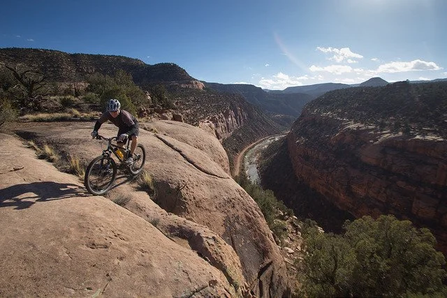
The West End of Colorado is a mountain biker's paradise, boasting a network of diverse trails perfect for all levels and riding styles. The trails traverse through juniper and pinyon forests, over expanses of slickrock and along miles of mining roads steeped in history.
Trailforks plugin
What To Expect
The West End is covered with hundreds of miles of old roads from mining operations of the past. With mines long closed, these roads are now being utilized by mountain bikers with a mind for exploration. While some routes offer scenic and mellow rides, some offer a more technical challenge in more remote setting.
Around the West End, we have a lot of what Paul Koski had coined “adventure riding”. Whenever you see that designation on a trail description, know you’re in for a few hours of backcountry riding with less trail grooming and more route finding, amongst the most beautiful landscapes. More advanced doubletrack trails are often janky, rocky and loose. This area is remote, rough and rugged, and perfectly suited for big days and big advetures on two wheels.

In addition to doubletrack, the West End has a number of singletrack trails reclaimed from years of use by cowboys and ranchers, as well as singletrack built by volunteers. The Camp V and Nucla Range trail systems, as well as the Paradox trail are great for intermediate and beginner riders.
Many trails around Nucla and Naturita can stay free from snow and rideable throughout the winter. Always refer to Trailforks or WETA Maps before heading out to familiarize yourself with the trail. Check Trailforks or the West End Trails Group for up to date trail conditions.
Our Favorite Rides

Shamrock Trail
The 9-mile Shamrock Trail (also known as Y-11) in Colorado's West End is a moderate challenge perfect for experienced hikers and mountain bikers. Start at the old iron bridge and climb through a piñon-juniper forest, enjoying stunning views of the San Miguel and Dolores Rivers. The trail alternates between smooth singletrack and exposed sections, requiring focus and skill from bikers. Hikers enjoy a peaceful walk with unparalleled scenery. Lace up your boots or grab your helmet and conquer the Shamrock Trail!

Range Loops
Less than a mile from town off the Delta Nucla Road is the Range Loops Trail System. Over two miles of interconnecting loops were created over the piñon and juniper covered ridge as it climbs though rock gardens and sometimes technical switchbacks. For mountain bikers, the system has earned an intermediate rating which the average rider may find challenging with some of the many fun climbs and descents. Down in the bottom of the drainage, you can add an extra loop by jumping onto the Paradox Trail which, if you have the time, offers over a mile of new single track trail to the north as it heads towards Coal Canyon.


Featured Ride:
The Paradox Trail
The Paradox Trail is a 118-mile long mountain bike trail that traverses the western part of Montrose County, Colorado. Beginning at the Tabeguache Trail on the Uncompahgre Plateau, the trail ends at the Kokopelli Trail in the La Sal Mountains. Mostly made up of doubletrack, with some hike-a-bike sections, the Paradox trail offers stunning views of the La Sal Mountains, the San Juan Mountains, and the Colorado Plateau.
Sections of the trail are easily accessible just north of the town of Nucla and make for great out and backs or loops with Mesa Rd. This portion of the trail is mostly made up of newly constructed singletrack and old jeep roads. The Paradox Trail is open to mountain bikes, hikers, trail runners and motorized users, and is open year round.
Whether you do an out and back from the end of the single track or keep going to Second or Third Park, the Paradox offers riders many fun riding options.
Upcoming Project
Sawtooth and Naturita Flats
78 miles of purpose built singletrack

Backcountry Safety
The West End is a wild, remote and rugged playground. There is little cell service and a network of thousands of roads and trails. Many of our backcountry trails require route finding skills and take you great distances over challenging terrain. Be sure you’re prepared for those big backcountry adventures:
Bring plenty of food and always more water than you think you’ll need.
Have a small first aid kit and bike tool kit. It’s not uncommon to be the only person for miles out here, you have to be self-reliant.
Check the weather forecast before you go, storms can move in quickly. Many roads can become muddy and impassible when wet.
Bring a map, download offline maps and familiarize yourself with the trail before heading out of service.
Let someone know where you are going and when you expect to be back.
It’s always best to ride with a friend.
Did you know? Calling 911, even when your phone shows no service, can alert the authorities to your location
